Posts

Showing posts from 2013

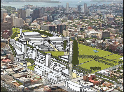
Week 12 - 22 May 2013 - City Village in Green Square (Sydney City)

Image
22 May 2013 - City Village in Green Square (Sydney City) The Green Square is a crucial design project highlighted by Sustainable Sydney 2030 for resolving the inner-city high-density residence problem and providing a new multi-functional city village. It also has been an dispensable part of the green connection with Sydney City, which it provide people a potential town centre with local advantages linking with ten main green corridors to the liveable network of Sydney. Firstly, Green Square is the wider part of Sydney City to provide people to afford housing space and live in the city due to the diverse population. Therefore, this area has been contributed to a sustainable place for supplying a long-term opportunity of future development. Secondly, this proposal in Green Square has designed a new town centre supported by additional residential spaces, retails, business activities and enhanced public transport system. This area should be able to liveable city village for Sydne...

Week 12 - 21 May 2013 - Sydney Liveable Green Network

Image
21 May 2013 - Sydney Liveable Green Network A great many residents of Sydney City choose walking and cycling across the metropolitan Sydney; hence, a liveable green network was promoted into the entire sustainable travel patterns of the city in Sustainable Sydney 2030 , which residents and travellers would be managed to walk in 3 minutes to involve into the green link of this metropolitan city; then, they could follow ten   main green corridors to arrive a public open space existing in the city centre, which discovering attractions   in the city trip would be promoted in these green corridors. Firstly, the liveable green network of Sydney City would provide a more public city than before since open spaces and private spaces were connected by these main green corridors that original streets with plants, which the pedestrians and cyclists are able to be involved into a great trip of entire city to create a sustainable public life. Secondly, the crucial roads, air and r...

Week 12 - 20 May 2013 - Maroubra traffic resolving

Image
20 May 2013 - Maroubra traffic resolving   This journal is about a traffic changing project on Anzac Parade, Maroubra. The location is at the crossroad of Anzac Parade and Avoca St, near Snape St and Moverly Rd. The reason of choosing this project is that it has improved local traffic condition. Before, when vehicles turning from Anzac Parade to Avoca St at this location, there is only one right lane for waiting; hence, a lot of cars have to be stuck on this right lane for a long queue, especially in peak time of morning and afternoon in weekdays. However, this situation was changed by improving the laneways of this location. Green land in the middle of Anzac Parade of this location was redesigned and part of green land was involved into vehicle lanes, which there are two right lanes from Anzac Parade to Avoca St. Although green space was reduced, traffic problem in local area would be resolved by utilizing that green space, which car accident and traffic jam in peak time ...

Week 11 - 15 May 2013 - Central Park project, Sydney

Image
15 May 2013 - Central Park project, Sydney   Central Park is a multifunctional urban renewal project near the CBD of Sydney. It has been built on the former Brewery site, which it located on Broadway in the suburb of Chippendale. Central Park designed by many architects, like Foster + Partners (London), Ateliers Jean Nouvel (Paris) Johnson Pilton Walker, etc, is arrange to become an icon of 21 st Century living and claim as one of the world’s great urban destinations. Spectacularly it located 'downtown', at the southern edge of the CBD of Sydney.   Central Park is an urban village about 5.8 hectares with a beautiful, spacious park surrounding by grouped living structures, which it represents an exceptional destination for living, working, meeting friends, shopping, dining out and relaxing. The ambition of this project is called the City of Sydney’s ‘Sustainable Sydney 2030’ vision, which intent to create one of the world’s most liveable green cities within a 20-year ti...

Week 11 - 14 May 2013 - Redesign Central Station (Three City Squares of Sydney) by Sustainable Sydney 2030

Image
14 May 2013 - Redesign Central Station (Three City Squares of Sydney) by Sustainable Sydney 2030 The Central Station is the last stop for the Three City Squares linking by George Street. It will be redesign as a crucial southern public transport destination to the City and an open place for significant redevelopment over the rail lines and with a series of redesigned public squares. Redesign of the public domain would create easy walking connections above ground to surrounding areas, including Haymarket, Ultimo, Devonshire Street and Surry Hills, Chippendale and to City South. Since the development of the airspace over the rail lines the suburbs surrounding Central Station would be reconnected through new street system, with walking links following the traditional street pattern. Access by rail means future redevelopment could include major public facilities, including a Convention Centre.

Week 11 - 13 May 2013 - Central Station, Sydney

Image
13 May 2013 - Central Station, Sydney   Central Railway Station is located at the southern end of the Sydney CBD and it is one of the largest railway stations in Australia. It services almost all of the lines on the CityRail network, and it is the major final station between interurban and interstate rail services. It is one of the Sydney most recognizable landmarks and it is very popular among tourist as a meeting point. Central Station has seen a steady increase of passenger flows with the development of times. It used to be an interchange between trains and trams but now it is more recently used as changed station to buses, coaches and taxis. Central station was built in 1926 and has been used for over 100 years. In summary, this building is very magnificent and really contributes to Sydney transport a lot.    

Week 10 - 8 May 2013 – Redesign Town Hall (Three City Squares of Sydney) by Sustainable Sydney 2030

Image
8 May 2013 – Redesign Town Hall (Three City Squares of Sydney) by Sustainable Sydney 2030 The Town Hall Square is the middle open space in the Three City Squares. It is proposed as a new civic meeting place creating a civic centre like the European tradition. New plazas would be dominated by the Victorian architecture of the Town Hall, Queen Victoria Building and St Andrew's Cathedral, but new development of sustainable structures would create a contemporary edge. Redesign of the station and a new light rail system would make Town Hall Square become a gateway to connect with the southern entertainment precinct and Chinatown Haymarket to the south. The square would be a focal point midway along the City’s pedestrian thouroughfare—George Street—in the centre of the City.

Week 10 - 7 May 2013 – Town Hall underground train station (Sydney City)

Image
7 May 2013 – Town Hall underground train station (Sydney City) Town Hall underground train station opened on 28 February, it was built with 6 platforms in 2 two levels, which 4 platforms in lower ground level 1 and 2 platforms in lower ground level 2. This station is the second busiest railway station in Sydney City, which all people taking the train between eastern, western and northern lines are able to transfer from this station. Two reasons are for making this station become a flourishing area. Firstly, there is a under lane system connecting with between surrounding building basement levels, which it would enable pedestrians to walking through those underpasses   to create connection between their destination and the station easily. Secondly, many retails in basement level of surrounding buildings like Queen Victoria Building (QVB) and the Galeries Victoria will increase the crowds either shopping or just out from stations, w...

Week10 - 6 May 2013 – Town Hall house (Sydney City)

Image
6 May 2013 – Town Hall house (Sydney City) Sydney Town Hall is a landmark building in the heart of Sydney City.   It is a sandstone structure sanding opposite Queen Victoria Building and next to St Andrew’s Cathedral, which the popular meeting place in the Central Business District. In architectural aspects, The Sydney Town Hall was inspirited by the Beaux-Arts tradition, with a heavily articulated facade of neo-Classical features designed to express the seat of civic power. The Town Hall area has been defined as a social space in the location, which it has been embraced by a large scale of city central business and commercial area. Town Hall building has not only been seemed as a major city landmark for historic heritage in architecture aspect, but also it has provided a meeting point, a traffic junction and social activity place.   Opposite Woolworths Town Hall has supplied household products to people ...

Week9 - 1 May 2013 - Redesign Circular Quay (Three City Squares of Sydney) By Sustainable Sydney 2030

Image
1 May 2013 - Redesign Circular Quay (Three City Squares of Sydney) By Sustainable Sydney 2030 According to Sustainable Sydney 2030, Sydney City could create a link by three city squares for increase public life, which they are Circular Quay, Town Hall and Central Station linking by George Street. Circular Quay could be redesigned as a new harbour gateway to the City with the design of a new public square with better access and views to the water. Customs House Square would be seemed a new natural celebrated gathering place in a harbour City and renew Sydney’s representation nationally and internationally. Concepts for Circular Quay propose removal of the Cahill Expressway and celebrating the station as an arrival and transaction to a proposed light rail city circle. When visitors start to move from the Circular Quay to south, they would be able to present more challenges and attractions.    

Week 9 - 30 April 2013 - Circular Quay train station, Sydney

Image
30 April 2013 - Circular Quay train station, Sydney S ydney Cove, the current site of Circular Quay, was the site of the initial landing of the First Fleet in Port Jackson in 1788, which it could be called the “water gate” of Sydney city. It was originally designed for shipping, transport, leisure and recreational centre. The opening of Circular Quay Station in 1956 marked the completion of the essential City Circle train line system, which now conveys thousands of commuters, shoppers and tourists around the CBD every day. Before that time trains began their trip from either Wynyard or St James. Circular Quay is a focal point for community celebrations, due to it is the central location between the Sydney Opera House and the Sydney Harbour Bridge. As well as, The Rock precinct near this station has supplied a motivation for visitor stopping at this station to enjoy many old and current cultural elements such as Museum of Contemporary Art, the City of Sydney Library and the Custo...

Week9 - 29 April 2013 - General Post Office (Martin Place),Sydney

Image
29 April 2013 - General Post Office (Martin Place),Sydney The General Post Office is a landmark building in Sydney City, which is located at the western end of Martin Plan, between George and Pitt Streets. This building was established as a monument that symbolizes the city. The reason why I choose this structure is that this building has been changed for many purposes during the time, which it is changed from a large post office building to a part of Westin Hotel, Sydney. This heritage has utilised until now but not be demolished by the rapid development of the city. The exterior facade is showing the Renaissance Palazzo style by sandstone, which becomes an important signal element in this central business area of Sydney; while the interior space has created a fusion between the refurbished existing walls, a lobby with glass metal structure mansard roof and new hotel facilities. It is obvious that this building i...

Week8-24 April 2013 – Paling Lane (Martin Place),Sydney

Image
24 April 2013 – Paling Lane (Martin Place) There are many attractive lanes existing in the big pattern of Sydney City, Paling Lane is one of them to provide attractions for visitors to discover in this city. It was named because it led through to the large 1880s Palings Building in Ash Street. William Henry Paling was a musical entrepreneur who imported and eventually manufactured pianos and sheet music. In 1890 Paling moved his piano and music warehouse to the Sydney Safe Deposit Building in Ash Street, Upper floor rooms in Palings building, and many others in this area were rented out to teachers of music and dance, and as artists’ studios. Ash Street also housed the headquarters of the Liberal Party of Australia for many years. In 2008, Palings Lane was relocated further north, which it continues to provide a pedestrian connection with Ash Street and interprets the late 19 th century urban laneway patterns.    

Week 8- 23 April 2013 –– Ash Street (Martin Place), Sydney

Image
23 April 2013 –– Ash Street (Martin Place), Sydney The main streets are transport media for vehicles, cyclists and pedestrians, which give people a flourishing vision; but quiet laneways create another vision only by pedestrians and high structures. Ash Street is the connection between Angel Place and Paling Lane, which it has included many elements, such as heritages, artworks and entertainment. Palings Building is a heritage site existing in this street, “Forgotten Songs” artwork has been designed in Angel Place near this street and Ash Street Cellar could be seemed a entertainment place to provide restaurant, bar, hotel functions to people.   The diversity of subculture has been involved into the local urban design, which it does not to be necessary to only care management but less care its essence.

Week 8 - 22 April 2013 – Angel Place (Martin Place), Sydney

Image
22 April 2013 – Angel Place (Martin Place )   There are some small laneways might be not large width like the main streets in a city, but it could be able to bring about a different experience for pedestrians. Angel Place is one example that showing a quiet laneway was redesigned to create an artistic feeling for pedestrians. Angel Place features an installation known as “Forgotten Songs” designed by Michael Thomas Hill in 2011. A canopy of empty birdcages hanging in the sky, accompanied with the sound of Sydney’s lost birds which may have lived in this area, before the laneway replaced their native habitats.   Due to the rapid development of metropolis have accompanied with the large demolish of natural element, which this vision could be seemed a contradictory problem during centuries. However, this laneway is a good example that transferred those contradictory problems to a new sense for urban design with artworks.    

Week7 - 17April 2013 – Sydney Hospital

Image
17April 2013 – Sydney Hospital Sydney Hospital is a major hospital in Sydney, Australia, located on Macquarie Street facing to the Westside of Martin Place. It is the oldest hospital in Australia. The hospital site was constantly added to and modified to accommodate the growing population of Sydney after 20 th century, with a number of additional buildings erected in the hospital grounds facing Hospital Road. The most recent work was the construction of the clinical services building and accommodation for the Sydney Eye Hospital. Therefore, a small garden with a fountain was created in the middle of hospital area, which Administration block has created a barrier between the noise Macquarie Street and quiet hospital garden. This heritage site could be seemed an isolated area from the many high modernist structures of this metropolis; as well as, a shortcut run through from the financial and insurance centre – Mar...

Week 7- 16 April 2013 – the MLC Centre (Martin Place), Sydney

Image
16 April 2013 – the MLC Centre (Martin Place), Sydney The MLC Centre is a skyscraper in Sydney, Australia. This high level office building is 228 metres high and it has 60 storeys inside. The podium of the building includes a shopping centre at the bottom levels of this structure with several exclusive fashion labels and a 1,186 seat theatre, the Theatre Royal. The building is a stark white, modernist column in an octagonal floorplan, designed by Sydney architect Harry Seidler, with eight massive load bearing columns in the corners that taper slightly towards the top, which it is one of the world's tallest reinforced concrete buildings. There are two entrances being designed within this structure, one has been designed as an open space facing to Martin place for providing a good restaurant and coffee shop place and another has been seemed as the main entrance to the shopping centre and near the Theatre Royal. This structur...

Week 7- 15 April 2013 – Martin Place, Sydney

Image
15 April 2013 – Martin Place, Sydney Martin Place is s a pedestrian mall in the central business district of Sydney City. Martin Place sets between George Street and Macquarie Street, and provides the entrances to the Martin Place train station underground levels. Other cross streets including in Martin Place are Pitt Street, Castlereagh Street, Elizabeth Street and Phillip Street. Since a lot of significant structures involving into this place, such as the Reserve Bank of Australia, the Commonwealth Bank of Australia, etc; hence, it has been promoted as ‘financial and insurance centre of Sydney’ and ‘the hub of the city’. Approximate 30 metres width public pedestrians mall combining with different styles of building of each side, many natural and artificial elements including in this sits such as public seating,   plants, daylight and crowed office workers and travelers has contributed a urban public life vision in this s...

Week 6- 10 April 2013 – Federation Square, Melbourne

Image
10 April 2013 – Federation Square, Melbourne   Federation Square is a new civic square and cultural precinct opening up for public use in the city of Melbourne, Victoria, Australia. It is a multi-functional development project covering an area of 3.2 hectares including cultural and commercial buildings and an open amphitheatre capable for 15,000 people. It is also a large scale public square setting in the most flourishing central business district above the Melbourne City’s major transport hub – Jolimont Railway Yards. It is a good example that identifying the new direction for public square, which various topography was created by architectural method like stairs, ramps or structures, as well as, spectacular location connecting with local features has creates a new vision for urban heart design theory.    

Week 6- 9 April 2013 – Flinders Street Station, Melbourne

Image
9 April 2013 – Flinders Street Station, Melbourne Flinders Street Station is a central commuter railway station at the corner of Flinders and Swanston streets in Melbourne, Victoria, Australia, which it has served the entire city railway network. Near the Yarra River Backing onto the heart of the city, the complex covers two whole city blocks and set on the corner between Swanston Street and Queen Street. It was the first railway station in an Australian city opened in 1854 and the first use of a terminus for steam rail in Australia.   This iconic structure also closes to the most flourishing street in this city - Swanston Street, its dome, arched entrance, tower and clocks has been become one of the most recognisable landmarks in this city. Its small open space is the most important place to provide the busiest pedestrians crossings between Flinders Street and Swanston Street.    

Week6- 8 April 2013 – Melbourne Town Hall

Image
8 April 2013 – Melbourne Town Hall                                              Melbourne Town Hall is the central municipal building of the City of Melbourne, Victoria, Australia. It is located on the northeast corner of Swanston and Collins Streets, which the central business and commercial district. This structure is one of the landmarks of Melbourne City that has been utilized for multiple purposes, such as theatrical activities, exhibition place, or a school concert. The facade of this Town Hall is showing the Second Empire style, which it was designed by local architect Joseph Reed in 1867.   The Melbourne Town Hall is either a magnificent heritage building or a signal landmark in the heart of the city.   A meeting place for people existing in the...

Week 4 - 27 March 2013 – Sydney Light Rail

Image
27 March 2013 – Sydney Light Rail Light Rail links the hub of Central Station and Sydney's Inner Western Suburbs via Haymarket, Pyrmont, Glebe and Rozelle. It is one of the most desirable transports in Sydney, with huge environmentally benefits.   This kind of the transportation is very popular due to the reasons below. First of all, it has more comfortable ride with high passenger capacity and lower operating cost. Secondly, it almost don not discharge any pollution from the vehicle and has lower noise. Thirdly, a well-designed light rail can add visual value to urban landscape and add positive benefits to property value. Lastly, it may more suitable for the areas where level of demand is between bus and heavy rails. However, it also has some negative effects. It has high capital costs but the route is inflexible. In addition, it can be easily disrupt during construction. In summary, light mail has much more environmental ben...

Week 4 - 26 March 2013 – Sydney Monorail

Image
26 March 2013 – Sydney Monorail The Metro Monorail of Sydney City connects Darling Harbour, Chinatown and the Sydney central business and shopping districts. There are eight stations with the total length of 3.6 kilometres of track, with four trains working every day except Christmas. Although this type of transportation will soon be taking down, it used to contribute this city a lot. First of all, monorail requires minimal both vertical and horizontal space. Secondly, as the length of monorail is smaller than traditional elevated rails, it is more attractive than it. And it only blocks a minimal amount of sky. Thirdly, it is much quieter than other trains as it uses rubber wheels on a concrete track. Fourthly, the speed and safety of monorail is much higher than the traditional ones. Lastly, the cost of build and maintain the monorail is much less than underground metro system. However, it also has some negative effects. The most ...

Week4-25 March 2013– Chinatown, Sydney

Image
25 March 2013– Chinatown, Sydney Sydney's Chinatown locates in the southern part of the Sydney central business district between Central Station and Darling Harbour. And it is Australia's largest Chinatown. This is a great place and will give visitor an exciting and rewarding experience. This place contains some of the best Chinese culture and offers some of the best festivals, shops, history, and traditional food. The food in Chinatown is great and extremely feature-rich, after whole day of shopping you can sit down and reset yourself. Furthermore, there are also numbers of markets and shops in Chinatown with numerous goods. If you walk through the streets and look to the sides, you will feel strong Chinese culture breath. You can find shops with brightly coloured traditional kites, or perhaps you would like to purchase some Chinese traditional herbs. In summary, Chinatown is a great place to be and pleasure the visitor a...

Week3- 20 March 2013 – Hyde Park, Sydney

Image
20 March 2013 – Hyde Park, Sydney Hyde Park is one of the oldest public park in Australia with area of 16.2-hectare in the CBD of Sydney. It is a chain connects parkland and extends north to the shore of Sydney Harbour. Hyde Park is approximately rectangular in shape, being squared at the southern end and rounded at the northern end. It is surround by Elizabeth Street in the west, by College Street on the east, by St. James Road on the north and Liverpool street on the south. This park is very quiet and popular among office workers who want some fresh air, a quick rest. The central pathway through the park is an impressive, tiled, fig lined road linking the Archibald Fountain and the War Memorial. There are plenty of free entertainments during holiday time.    

Week 3- 19 March 2013 – Queen Victoria Building, Sydney

Image
19 March 2013 – QVB, Sydney   The QVB (The Queen Victoria Building) was designed by George McRae and completed in 1898. It replaced the original Sydney Markets and was named by Queen Victoria's Diamond Jubilee. It was built during Sydney's severe recession. This building used to have a concert hall, coffee shops, showrooms, warehouses and a wide variety of trades people were accommodated, however with time changes, the concert hall become the city library, offices proliferate and more tenants moved in. This building contains full of classic breath and it is a multifunction building. When you walking through QVB, you will appreciate stained glass windows located on level 1 and 2, centre dome area. In addition, Queen Victoria Bronze Statue locates on the forecourt is worth looking. Shopping in QVB is also a great thing. In QVB, you will authentic Australian products, pearls, fine art and souvenirs. It has the best of Sydney's contemporary ladies and men's fashion, s...

Week 3- 18 March 2013 – Westfield in Sydney City

Image
18 March 2013 – Westfield in Sydney City Westfield has been one of the most powerful landmark structures in Sydney CBD, with three complete refurbishment shopping centre together. It offers world’s most exclusive and luxurious brands to consumers. Furthermore, this mall has three facades include Castlereagh Street, Pitt Street, and Market Street will have two levels with shopfronts and remaining upper levels of retail with glazed facade, which give a deep and attracting visual impression for people walking on the street level. In addition, in order to fit the Tower into the 21st century, the interior finishes for floors and ceilings, and reconfiguration of existing voids and open space are refurbishment to better serve and attracting shopper. Furthermore, new system of escalators has also been installed. The systems facade to 85 Castlereagh Street is believed to be the first commercial use in Australia as it has a thermally enhanced curtain wall framing system with high sealing pe...

Week2-13 March 2013 –The Rocks precinct, Sydney

Image
13 March 2013 –The Rocks precinct, Sydney The Rocks is a historic place that represents the present and the past of one of the most important cities in Australia: Sydney. The Rocks is located in the city center. There are a number of historical buildings such as warehouses, homes of sailors and many more that have been built approximately two centuries ago. Presently, all of these all buildings are state-owned, saving it from demolition and trying to preserve it and protect the suburb´s cultural value. Many of the historical buildings in question are used as modern shops, boutiques, restaurants, nightclubs, galleries and unique stores. When ´The Rocks´ is mentioned to tourists as a unique place to visit, the mental image they make of the place is far from its reality. It can be a splendid surprise when one visits this suburb, as it is a combination of the best of Sydney´s past and present. The location of this place is perfect, while you are walking there you can see “The Sydney O...

Week 2- 12 March 2013 - Centennial Park, Sydney

Image
12 March 2013 - Centennial Park, Sydney Centennial Park is a large public, urban park that occupies 220 hectares in the Eastern Suburbs of Sydney. Centennial Park located 4 kilometers south-east away from Sydney CBD, in the Randwick. The Park forms part of the larger Centennial Parklands. The park is not only a 'natural' landscape but also constructed horticultural contains a lot of aesthetic and landscape traditions. It has also been designed in order to better serve people’s health, race, social order and the influence of environment on people (known as environmental determinism or euthenics). The urban values have been increased due to this park. This park is a great place for reading and relaxes in side. During weekend, many parents will bring their family there and enjoy the time contacting natural and play with family members. All of these influences have been marked; Centennial Park today is a large and great place on landmark.